Not so much a hike as a shortish stroll through those parts of Vienna rarely featured in tourist brochures. All in pursuit of examples from the famous social housing programme of the 1920s and early 1930s.
- Takes you past classic examples of Red Vienna’s municipal housing complexes
- Architecture ranges from the bland to the intriguing
- Easily reached on public transport (U1 and U4 subway lines)
- See also:
The social housing trail

(The Reumannhof complex features on the walk)
While the other official hiking trails in Vienna tend to focus on walks through parks and woodland, up hills, and along rivers, Number 11 remains unashamedly urban. Nor is it particularly long: we were done in half a morning.
The route takes you down shopping streets, along ring roads, and past building sites, carefully avoiding any of the notable historical buildings featured on tourism Instagram channels.
Which might leave you wondering quite why you’d bother.
The answer is social housing (something else rarely found on the front of guide books).
Ah, but Vienna’s municipal housing complexes have a special place in world urban history, particularly those built between the end of the first world war and the establishment of a fascist state in 1934.
The exalted status of these buildings comes from the remarkably forward-thinking holistic design and the long-term impact on the city’s landscape and social fabric.
Even today, urban planners across the globe see them as role models (though property developers and private landlords have a different opinion). See here for the full explanation.
The Wanderweg 11 hiking trail shows you several examples and also offers a peek into parts of Vienna where you may be the only one looking at a map.
Here’s the official route, kindly provided by the city of Vienna:
Let me take you through the highlights, beginning at the southernmost end:
Amalienbad
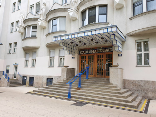
(Completed in 1926)
The Wanderweg begins at the Amalienbad, a large public swimming pool complex built as part of a campaign to improve the health and hygiene of the broader population.
As with so many of those historical constructs, the building retains its original use (with modern improvements, obviously).
The adjoining Reumannplatz square is named after Jakob Reumann (1853-1925): a former mayor of Vienna and a major proponent of the whole social housing initiative. Before you leave, consider popping across the square for an ice cream. The family-run Tichy salon enjoys city-wide fame.
The route then takes you up Favoritenstraße and past the Viktor Adler market.
Both locations offer a flavour of Vienna away from palaces and emperors, where pensioners and young migrant families alike take advantage of the local shopping opportunities.
Zürcher-Hof and Amtshaus

(The frieze above the main entrance has farmers on the left and workers on the right. It perhaps honours the socialist premise behind the housing projects)
Shortly beyond the market lies the Zürcher-Hof public housing complex, completed in 1931. Architects Emil Hoppe and Otto Schönthal both studied under the great Otto Wagner. Schönthal also designed the Jugendstil Mozartbrunnen fountain over in the 4th district.
Hof translates literally as courtyard, which is why so many of these housing complexes have Hof in their name. Most were built around a central open area, reflecting the wish to give inhabitants access to recreational green spaces.
(The rest of the name typically honours a personality or location: later you’ll come across Reumannhof, for example.)
They renamed the complex after the city of Zürich in 1949 in recognition of the Swiss city’s relief efforts on behalf of the post-WWII Viennese population.

(Impressive looking municipal offices)
The historical-looking building (pictured above) just beyond the Zürcher-Hof as you walk down Laxenburger Straße is the Amtshaus for Favoriten (main home of the government offices for Vienna’s 10th district).
The Gürtel housing complexes
Wanderweg 11 now takes you onto the Gürtel, which you’ll follow around to the end of the trail.
Think of the Gürtel as Vienna’s internal ring road (not to be confused with the Ring roads!). So expect plenty of traffic. Not always the ideal place for a pleasant stroll, though the central reservation can be quite broad with some park like areas.
For our purposes, the areas flanking the Gürtel feature many of those characteristic social housing projects.
Julius-Ofner Hof
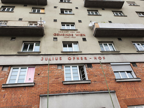
(Not pretty, but effective)
The route first takes you past Julius-Ofner-Hof, completed in 1927 and designed by Ernst Lichtblau. Lichtblau was another Wagner student and also worked with Josef Hoffmann at the Wiener Werkstätte.
Matzleinsdorfer Hochhaus
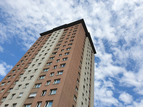
(High-rise buildings remain relatively unusual in Vienna, at least in the centre)
A little further on and you reach the massive Theodor-Körner-Hof, built in the early 1950s. Perhaps the most notable element is the so-called Matzleinsdorfer Hochhaus: a 20-storey high-rise apartment block.
Julius-Pop-Hof
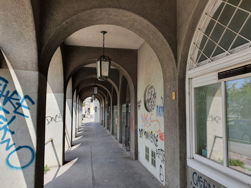
(Even Vienna can’t escape the spray can)
Continuing around the Gürtel eventually takes you through arcades belonging to the Julius-Pop-Hof, opened in 1926 and named for one of the driving forces of the worker’s movement of the late 19th century.
Metzleinstalerhof

(The complex that started it all)
The Gürtel then curves up toward the north and brings you to the Metzleinstalerhof, formally opened in 1925. It holds the distinction of being Vienna’s first social housing project to be completed after WWI.
A newspaper of the time noted in its report of the opening (my translation) that every apartment:
…has its own cooking niche with a two-flame gas cooker, an oven…and a two-piece sink with its own water supply
Reumannhof
(One of the more picturesque buildings)
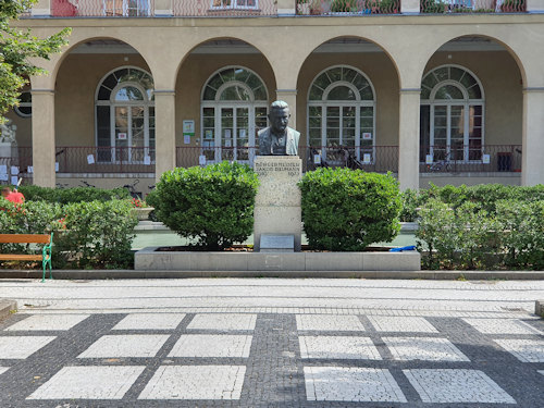
A near neighbour of the Metzleinstalerhof is the Reumannhof (opened in 1926), which is one you should definitely wander into.
The central courtyard of the complex has an almost palace-like feel to it that includes arcades and a large water feature behind a statue to Jakob Reumann (who we met earlier).
Haydnhof

(Vienna also has a Beethoven-Hof in the 21st district)
The trail ends officially at the Bruno-Kreisky-Park next to the River Wien (German: Wienfluss), but not before taking you past a couple more examples of social housing. One is the Haydn-Hof.
The name is no coincidence for this is Joseph Haydn territory. In fact, you’re close to his first burial place (the Haydnpark) and not too far from his long-term residence in Vienna at the Haydnhaus (now a museum).
Haydn himself never experienced the Hof that took his name, which opened in 1929 (more than 200 years after the great composer’s death).
Once you’re done, you might follow the River Wien downstream. The footpaths eventually take you to the huge Naschmarkt open-air market and a couple of Jugendstil jewels: the Majolikahaus and the Secession building.
How to get to the start / finish
Unlike most of Vienna’s hiking trails, this one is linear, rather than circular. So you should choose either end as your start (or finish).
The end furthest away from the city centre (Amalienbad) adjoins the Reumannplatz stop on the U1 subway (which you can catch in the city centre at Stephansplatz, Schwedenplatz or Karlsplatz).
Leave the platform in the direction the train travels from the centre and take the left-hand exit to emerge more or less in front of the Amalienbad.
The end nearest the city centre is next to the Margaretengürtel station (a stop on the U4 subway line that also passes through the central Schwedenplatz and Karlsplatz stations).