The Danube has done much more than give its name to a waltz or two. A new exhibition at the National Library pays homage to the river as transport route, geopolitical icon, and source of creative inspiration.
- Invites you to explore the many faces of this renowned waterway
- Features a huge reproduction of the 19th-century Pasetti map
- Runs May, 2021 – Jan 30, 2022
- Just needs a normal ticket to the library’s State Hall (Prunksaal)
- See also:
A journey into the past
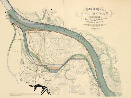
(Stephan Weiß (illustrator), Plan of the Danube in Vienna with the draft regulation plans of Florian Pasetti, 1864, Sammlung Wien Museum; reproduced with permission under the terms of the CC0 licence)
Many great rivers have made the jump from mere geography to an intimate association with arts, culture, and history. The Danube is one of them.
Vienna’s rise from a Roman outpost to imperial city owes much to its advantageous location on the banks of this famous river, and composers, artists, and writers have immortalised the Danube’s waters in music, painting and print.
The National Library in Vienna pays tribute to these cultural associations with an exhibition that looks at the Danube from multiple perspectives, illustrating various themes with items from the archives.
So we have, for example, the Danube as a motif in the landscapes of Jakob Alt (1789 – 1872).
In the early 19th-century equivalent of a coffee table book, over 250 pictures by Alt appeared in the publication Donau-Ansichten vom Ursprung bis zum Ausflusse ins Meer (Views of the Danube from its source to its outlet in the sea).
Although the exhibition explores the Danube as a wellspring of creative inspiration, it also highlights the river’s role as a transport route for people and goods and as a geographical element that both divides and joins.
The Danube played a key geopolitical function even back in fabled days of yore. It often marked, for example, the border between the Roman empire and the Germanic tribes. And it stood as a watery testament to the power and reach of the Habsburg empire.
The prime item in the exhibition is a 44m long reproduction of the Pasetti map of the river from the 19th century.
This reproduction covers the path of the Danube from Passau (on today’s German-Austria border) to the Iron Gates gorge (on the Mordor-Gondor Serbia-Romania border).
The original map played an important sociocultural role in highlighting the Danube’s importance to Austria-Hungary. Today, it describes a river that no longer exists, as man and geology have shifted the Danube’s form and position.
Pasetti’s drawings have incredible detail. Be sure to see the section covering Vienna and its environs. The city centre and outlying districts had yet to grow together at the time so you can still see the old town within its fortified walls and surrounded by an open space.
Dates and tickets
Wander the banks of the Danube from May 4th, 2021 to January 30th, 2022. The exhibition takes place inside the State Hall of the National Library, itself an extraordinary Baroque masterpiece. So a normal entrance ticket (or a relevant sightseeing card) includes the exhibition.
How to get to the exhibition
Just follow the travel tips at the bottom of the State Hall article.
Address: Josefsplatz 1, 1010 Vienna

