Given it’s the capital and way, way bigger than any other Austrian city, it’s strange to find Vienna nowhere near the centre of the country.
- Vienna lies right in the east
- Location a legacy of the days of empire
- See also:
Why not in the centre?
Austria is just under 600 km (373 miles) in length. Yet Vienna is so far east that the city limits are only about 30 km (17 miles) from the border with its eastern neighbour, Slovakia.
Vienna actually lies further east than the capitals of Czechia (Prague) and Croatia (Zagreb). Paris is almost closer to Austria’s western border than Vienna is.
So far off to one side seems a strange place to put your capital. Ah, well, blame history…
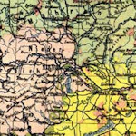
Prior to WWI, the city sat at the head of Austria-Hungary, a huge empire that stretched much further north, east and south than today’s Austria. Vienna was actually in the western part of that empire: see the red dot on this map:

(The location of Vienna in the Austro-Hungarian Empire)
Austria-Hungary disintegrated post-WWI, leaving behind Vienna as the capital of “just” Austria (roughly the pink patch to the city’s west on the map).
So Vienna’s position is a historical anomaly: almost overnight it shifted from its western position in a large empire to its eastern position in a small republic.
All this also explains why Vienna is so big.
The “Imperial city” attracted a huge population from the empire and beyond: people looking for work, influence, music, culture, etc.. And many stayed after 1918.
Vienna’s population is now just over 2 million, which makes it large even by US standards. The next-biggest city in Austria (Graz in the province of Styria) has a population of some 300,000.
One bonus of the unusual location is you can reach Slovakia, Czechia and Hungary very quickly. For example, a car drive takes you to any of their respective capitals (Bratislava, Prague and Budapest) in no more than 3-4 hours.
And, although Vienna is not in the Alps, the mountains are nearby, too. The first proper ski resorts begin around an hour’s drive away to the southwest, and the alpine foothills are even closer.